A chilling map has exposed the devastating consequences that could result from a Russian nuclear attack on three key targets across the UK, as World War 3 anxieties continue to escalate. In the latest ominous warning to emerge from Moscow, Sergei Lavrov, Russia’s veteran foreign affairs minister, outlined this week the conditions under which Vladimir Putin might launch an assault on Europe.
In remarks that only serve to heighten concerns about a full-scale confrontation with Europe, Lavrov condemned Britain and EU nations whilst lauding Donald Trump as he pushes his 28-point Ukraine peace proposal. This represents just the most recent in a string of menacing threats from senior Russian officials in recent weeks.
Only today, Russia’s propaganda apparatus has declared that acknowledging British armed forces’ presence in Ukraine constitutes a “casus belli” for a nuclear attack on Britain, with Kremlin mouthpiece Vladimir Solovyov stating on his program, “Now a nuclear strike on Britain is inevitable….”

Earlier this month, reports emerged that Dmitry Rogozin, a Russian senator and military veteran, had shared a list of strategic British targets for potential Russian assault and cautioned that Britain could become “deadly dangerous.”
In equally troubling remarks, Putin adviser Sergey Karaganov recently declared on Russian state broadcaster Russia-1 that “this war will not end until we defend Europe—morally and politically.”
But what would a conflict with the UK actually look like if Russia unleashed some of its staggering arsenal of 5,580 nuclear warheads?
An interactive map designed to demonstrate the impact of such an attack, called NUKEMAP, gives us a glimpse into the potential devastation zone and the horrifying combined death toll of roughly a quarter of a million people.
According to Gene Sticco, a national security expert and former Air Force nuclear protection specialist, we should “avoid anywhere near the US and NATO facilities.”
He added, “Otherwise, the key military centers are Telford, Plymouth, South Yorkshire, and the South East and South West of England.”
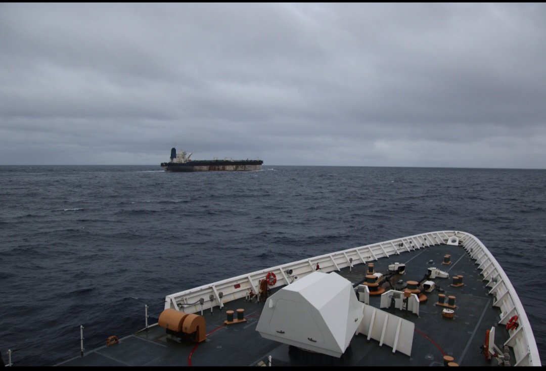
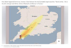
If an attack happened tomorrow, however, Gene believes the most probable target would be “naval centers—this is the UK’s strength and lifeline. Strike at Plymouth and Barrow-in-Furness.”
If we assume that the UK would face an attack from the 800-kiloton Topol (SS-25), which the site says is currently part of Russia’s arsenal, the consequences would be catastrophic.
It would kill an estimated 133,510 people, wound 85,830, and create a fireball stretching 1.28 km (5.16 km²). Its heavy blast damage zone would extend 2.02 km (12.8 km²), and the resulting radiation would cover 2.43 km (18.6 km²).
In the chilling image above, the blast appears to reach approximately 285 miles from Plymouth, Britain’s largest naval base, stretching nearly to Peterborough, with the map showing a thermal radiation (causing third-degree burns) zone of 9.7 km (296 km²).
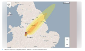
Applying the same principles to Telford, which houses a crucial Ministry of Defence facility at Donnington, yields equally disastrous outcomes. The estimated death toll stands at 71,350 people, with another 49,040 injured, as well as mirroring the blast figures mentioned earlier.
The map shows this blast stretching northeast towards Scarborough (a distance of roughly 173 miles) and extending beyond the coastline into the North Sea.
Furthermore, the map indicates that radiation would eventually claim the lives of 15% of survivors due to cancer caused by exposure.
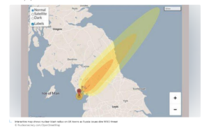
In a scenario similar to Telford, a nuclear strike on Barrow-in-Furness—home to the only UK site capable of designing and building nuclear submarines for the Navy—would also extend beyond the coast into the North Sea.
Echoing the previously outlined blast figures, the explosion would result in an estimated 54,060 fatalities and 12,620 injuries. The graphic illustrates a blast spanning the width of Northern England, just below the Scottish border and narrowly avoiding Carlisle.
The map further reveals that the light blast damage radius would span a staggering 10.9 km (375 km²). In total, the estimated death toll from all three strikes would reach 258,920.
Curled from The Daily Star Uk